
Smart GeoSurvey
According to the rhythm of the seasons, you can meet Andrea Liverani at the edge of a corn field, or alfalfa one, or a vine.
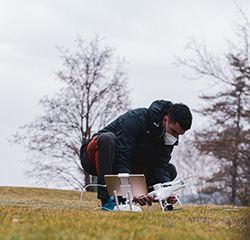
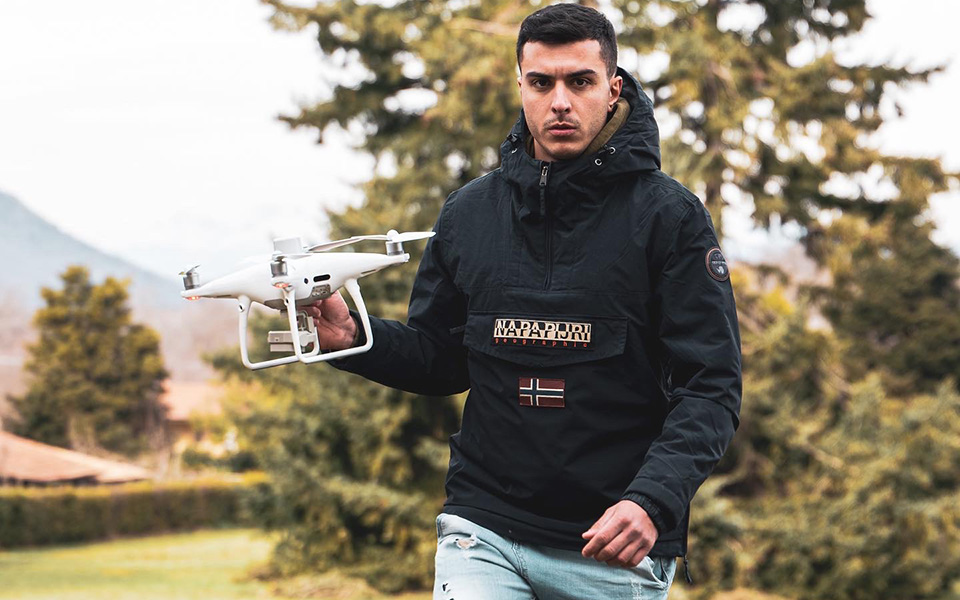
All his equipment neatly arranged on the car’s trunk, a look at the mobile station that perfects the positioning, and another lost in the sky, where the drone is a buzzing intuition. The small aircraft draws obliquus lines over the crops, it photographs and reports the data on the tablet, which has become part of the control pad: an x-ray that describes the health of the crop, the critical issues caused by pathogenic attacks, fertilization and water stress.
On the screen, the fields become expressionist palettes of yellow, red and green, that help farmers to plan irrigation and the administration of pesticides. Only where it is needed: the agriculture of the future can save up to 30% of water resources. A groundbreaking innovation in areas such as that of Oristano, which climate change has in recent years forced into dramatic periods of drought.
“I love my territory. The countryside, the ponds, the sea. I like to think that my work contributes to their conservation, keeping production and environmental needs in balance", Liverani often repeats. He spends part of his free time in the fields or the factories of the family business. Barely twenty-five years old, Liverani brings on an ancient tradition, he renews it, adapting it to the challenging context of the 21st century.
It all started with a diploma taken at the Logistics and Transport Institute, followed by all necessary courses to obtain all the SAPR (remotely piloted aircraft system) piloting certificates. The first collaborations with Coldiretti and the MEDSEA Foundation then arrived, within the Maristanis project. And the first important awards shortly after: his drone for precision agriculture won the last national Coldiretti Green Oscar in the "Networking" category. Collaborations soon expanded to form a team, the startup named “Smart Geo Survey”.
A drone, a pilot, two engineers and an agronomist who observe and analyze our world from above, capturing imperfections, wasted water resources and opportunities as you could not do from the ground. Engineer Francesco Petretto deals with the civil and industrial sector, while his colleague Alessandro Idda works on the hydraulic one. Francesco Barracu, agronomist, is instead responsible for drafting the innovative reports, based on the multi-spectral analysis of drones.
“Joining the MEDSEA Blue Community is certainly a source of pride for us. It is one of the first networks in Italy for the protection of the sea and the environment, and will allow us to implement our ideas and export our best practices, with the common goal of acting for the good of our territories, which constitute a unique heritage”, explains Liverani.
The network, first of all...
Contacts
Smart GeoSurvey
According to the rhythm of the seasons, you can meet Andrea Liverani at the edge of a corn field, or alfalfa one, or a vine.
All his equipment neatly arranged on the car’s trunk, a look at the mobile station that perfects the positioning, and another lost in the sky, where the drone is a buzzing intuition. The small aircraft draws obliquus lines over the crops, it photographs and reports the data on the tablet, which has become part of the control pad: an x-ray that describes the health of the crop, the critical issues caused by pathogenic attacks, fertilization and water stress.
On the screen, the fields become expressionist palettes of yellow, red and green, that help farmers to plan irrigation and the administration of pesticides. Only where it is needed: the agriculture of the future can save up to 30% of water resources. A groundbreaking innovation in areas such as that of Oristano, which climate change has in recent years forced into dramatic periods of drought.
“I love my territory. The countryside, the ponds, the sea. I like to think that my work contributes to their conservation, keeping production and environmental needs in balance", Liverani often repeats. He spends part of his free time in the fields or the factories of the family business. Barely twenty-five years old, Liverani brings on an ancient tradition, he renews it, adapting it to the challenging context of the 21st century.
It all started with a diploma taken at the Logistics and Transport Institute, followed by all necessary courses to obtain all the SAPR (remotely piloted aircraft system) piloting certificates. The first collaborations with Coldiretti and the MEDSEA Foundation then arrived, within the Maristanis project. And the first important awards shortly after: his drone for precision agriculture won the last national Coldiretti Green Oscar in the "Networking" category. Collaborations soon expanded to form a team, the startup named “Smart Geo Survey”.
A drone, a pilot, two engineers and an agronomist who observe and analyze our world from above, capturing imperfections, wasted water resources and opportunities as you could not do from the ground. Engineer Francesco Petretto deals with the civil and industrial sector, while his colleague Alessandro Idda works on the hydraulic one. Francesco Barracu, agronomist, is instead responsible for drafting the innovative reports, based on the multi-spectral analysis of drones.
“Joining the MEDSEA Blue Community is certainly a source of pride for us. It is one of the first networks in Italy for the protection of the sea and the environment, and will allow us to implement our ideas and export our best practices, with the common goal of acting for the good of our territories, which constitute a unique heritage”, explains Liverani.
The network, first of all...
Contacts
Our voice from the territory
Legal head office: c/o Studio Associato Conti-Via Piemonte, 33-09127 Cagliari (Italy) - Headquarter: Via Nazario Sauro 1, 09123 Cagliari (Italy)
(+39) 070 0950439 | info@medseafoundation.org | medsea@pec.medseafoundation.org
Photos ©: Andrea Alvito, Maurizio Naletto
MEDSEA Logo designed by Stefano Asili